30.10.2013 Uncategorized
The slides (part 1 and part 2) from the X3DOM tutorial (given by Johannes and Yvonne) at the Digital Heritage 2013 conference in Marseille, France, are now online.
23.10.2013 Release
This month, X3DOM celebrates its 4th anniversary!
As a little “present”, we are proud to announce a 1.5.1 release of X3DOM. This release mainly contains fixes and corrections since the last 1.5 release. It is a maintenance update and recommended for all 1.5 users.
Most notable are the fixed bind behavior for transformed Viewpoint nodes, Viewfrustum matrix corrections, basic multi-touch support for other navigation types than examine, two new navigation modes, a beta version of DepthMode, BlendMode and ColorMaskMode, better normal map support in CommonSurfaceShader (if the “OES_standard_derivatives” extension is available), and last but not least support for 32-bit indices given that the new “OES_element_index_uint” extension is available. For a detailed list of changes please also refer to the CHANGELOG file.
Grab the frozen 1.5.1 version here. The cutting-edge development version (nightly build of git head) can be found here.
15.10.2013 Uncategorized
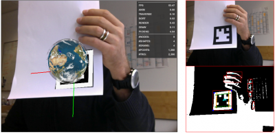
Three years ago, we did a first experiment with the Flash-based marker tracker FLARToolKit together with WebGL/X3DOM. However, at that time browsers did not yet provide an API to access the camera. Now, with the new WebRTC MediaStream API and a marker tracker implementation in JavaScript via JSARToolKit, we built a new version of that old AR demo, but this time without Flash or any other plugin to access the video stream. Try out the Augmented Reality demo here…
08.10.2013 Showcase
Another Fraunhofer project uses X3DOM to render a 3D web visualization: CityServer3D. The technology of the CityServer3D consists of a geo-database, a server with numerous interfaces for the import and export of the data and applications for the development of landscape models. This data can also be presented in a web browser using X3DOM to render the visualization. For instance, the city of Darmstadt: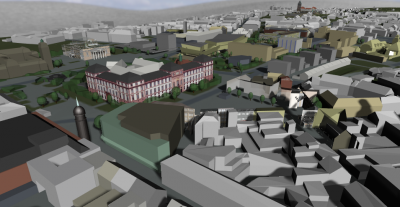
This representation has been rendered using the CityServer3D VIEW Service which provides complete 3D GIS applications based on integrated 2D and 3D data. Moreover, it offers direct access to geodata via a powerful web service interface.
07.10.2013 Uncategorized

X3DOM developer Max Limper will present the pop buffer paper tomorrow at the Pacific Graphics 2013 event in Singapore. The novel technique enables web applications to stream progressive geometry data in x3dom, and the implementation is part of the 1.5 release.
|